
It isn't that you see a 5 5 5!
Below is the Avalanche Bulletin for Banff, Yoho, and Kootenay National Parks
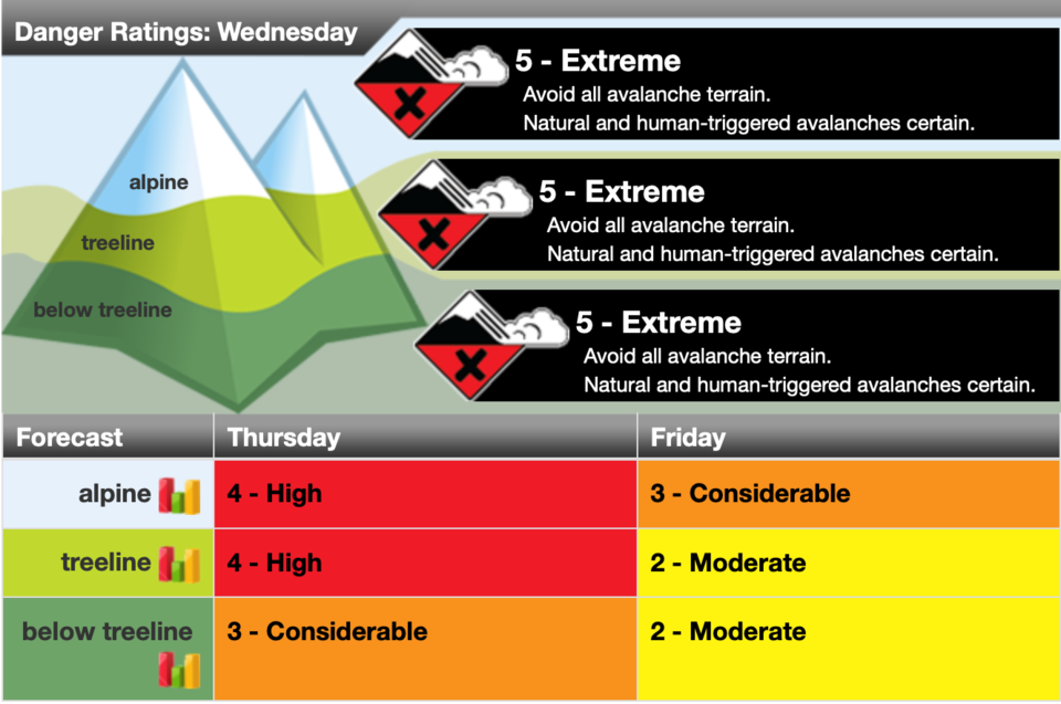
A significant storm is expected on Wednesday. It will be best to enjoy the ski hill and avoid all avalanche terrain.
40-100 cm of new snow and strong winds will create storm slabs at all elevations.
Deep Persistent Slabs 2.0 2.5 3.5 Very Likely - Likely Certain - Very Likely Certain
- Be aware of the potential for full depth avalanches due to deeply buried weak layers.
With a significant new snow load we expect to see larger and more frequent avalanches occur on the basal crust and facets. These avalanches have potential to run full path.
Dry Loose 1.0 1.5 2.5 Very Likely - Likely Certain - Very Likely Certain
- Use extra caution on slopes if the snow is moist or wet.
- Be careful of loose dry sluffing in steep, confined or exposed terrain.
Significant storm snow on Wednesday will create wide spread loose snow avalanches at all elevations.
Rain and warm temperatures below 2000m has potential to create loose moist avalanches as well.
Wednesday will be a crux day for avalanche conditions. 40-100 cm of snow is forecasted by end of day (more snow along the divide). This snow will be accompanied by very strong winds, high freezing levels and rain at lower elevations. Thursday will see convective flurries and clearing skies overnight. Freezing levels will drop to valley bottoms.
Natural and explosive triggered storm slabs have been observed at tree-line and alpine locations in past 48 hours. Many upper elevation storm slabs are stepping down to the deep persistent layer making for large class three avalanches. At lower elevations (below 1700 m) debris is gouging into isothermal snow and again making for large avalanches.
30-60 cm recent storm snow is reacting as a storm slab in alpine and tree-line locations. A crust (Nov 15) exists in the mid-pack in most areas below 2100 m. The Nov 5 crust/facet layer exists near the ground. Snowpack depths at tree-line average 80-110 cm. Lower elevation snow (below ~ 1600 m ) is rain- soaked and isothermal.
Read more – visit www.avalanche.ca


